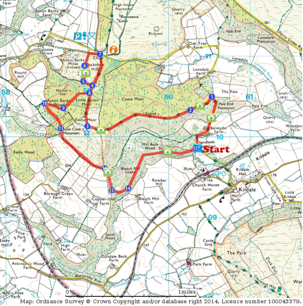
A medium length circular walk, starting and finishing just outside the village of Kildale. Photographic highlights include several viewpoints looking out over the Cleveland Hills escarpment, fine views of Roseberry Topping from Cockshaw Hill, woods that are particularly beautiful in autumn and a small waterfall.
Approach & parking:
Turn off the main (only!) Stokesley – Danby road in the centre of Kildale, signposted to the station, and then immediately turn right at the Glebe Cottage café. Follow this road under the railway and over a cattle grid, then along an unfenced section, slightly uphill to the corner of the wood. Park on the verge next to the stile into the woods.
The walks starts by heading up the road, past Bankside Cottage. At the first right-hand bend there is a path to the left through the woods. If time is short this takes you across to Waypoint 12, for a short circular jauntthrough the woods.
Viewpoint: Looking back down the road as you climb the hill gives good views of the Cleveland Hills across the valley, and the spire of Kildale Church.
1. Leave the road following the track to the left, with Cleveland Way fingerpost signposted “Gribdale 2 mls”
Viewpoint: Small paths to the left of the track lead through the woods to the edge of the escarpment, where there are more good views across to the Cleveland Hills
2. Footpath, fingerposted “Cleveland Way” leaves the track on the left, through the woods. Continue along this path, eventually through a wall onto the moorland.
Viewpoint(s): Good views across the heather to various parts of the Cleveland Hills, Captain Cook’s Monument and beyond to Roseberry Topping and Teesside
3. From Captain Cook’s Monument bear right, down the paved Cleveland Way
4. Follow the unmarked footpath to the left at a bench next to a low wall. This leads to the edge of the escarpment
5. The footpath follows the top of the ridge, and then along the top of the quarry. Take care of the edges – there are steep drops!
Viewpoint: There are great (if well-photographed!) views from here (Cockshaw Hill) across to Roseberry Topping, with varied foreground interest from gorse, heather or bracken depending on season, and the rocks of the quarry and pool below.
6. Drop down (back on yourself) at the end of the quarry, and then follow the narrow footpath through the bracken towards the road
7. Gribdale Gate car parking and picnic area. Follow the track back up the hill from here towards Captain Cook’s monument
8. About 100m past the bench where you left the road earlier (4) turn right along a track
9. The path bears right along the contour line before picking up a track from the left that heads steeply downhill through the woods. It can be slippery here!
10. At the bottom of the descent a track crosses. Go left, slightly back uphill and out of the woods.
11. When the track bends sharply back on itself to the right take the short footpath directly ahead to drop down to join the footpath that follows the field wall.
12. At the start of the woods the path goes through a gap in the wall. Turn right and follow the path downhill
Viewpoint: Good views across the valley to the Cleveland Hills, with bracken providing foreground colour & interest
13. Follow the path (marked ‘concessionary path’) all the way down to the river at the bottom of the valley. Initially this is a track – until about half way down you will see a field gate through the wall on your right. At this point don’t follow the track as it veers left, but continue downhill on a narrower path. This descends steeply, and heads left, until the river is reached.
14. From here the path follows the river upstream, through deciduous woods that provide a fine spectacle in autumn.
Viewpoint: Along the way you will come across a small waterfall – which can be reached by a short indistinct path off the main track. It is difficult to get a ‘clean’ picture of the falls, due to a number of overhanging and fallen trees, but some good segments can be taken – especially if you have wellies on to wade out into the river.
15. Follow the track back to the stile, and your starting point

Download a description and map of the route as a pdf file.

View a gallery of photographs taken along the route

See the route on the Viewranger website