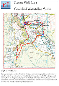
A circular route with a number of moderate climbs and some potentially muddy riverside tracks. It visits four of the large waterfalls around Goathland, with many other smaller falls and rapids worth viewing. There are also good vantage points for the North Yorks Moors Railway, if you choose the correct times to see the trains. There is a nice combination of some moorland scenery near the start and finish with riverside paths through the centre section.
Each waterfall is worthy of an hour or so of photography itself, and is accessible directly from nearby roads, so it might be best to consider this walk as a good opportunity to reconnoitre, giving yourself the opportunity to pick some spots to come back to at a later date.

Approach & parking: Car parking is available in the public Pay & Display car park just town-ward of Goathland station. The walk starts here head back to the main road and turn left towards the station.
1.
As the main road bears right follow the smaller road down to the
station. Cross the tracks through the pedestrian gates, or by the
footbridge if the trains are running
2. After crossing the tracks take the lower footpath to the left, signposted ‘Darnholm’.
Viewpoint – railway: As the path descends into Darnholm there are good views along the railway track, particularly for trains heading from Grosmont into Goathland
3.
In Darnholm join the road (either by crossing the footbridge over the
river, or directly from the path) and turn right. About 20 yards past
the river take the footpath to the left, go left again across the
footbridge and up the steps out of the valley.
4. Turn left across the stile.
5.
The path goes through a farm and through a gate into the field beyond.
Crossing the field there are views again of the railway below, at some
distance.
6. A footpath to the left drops down to the river at the railway bridge and footbridge
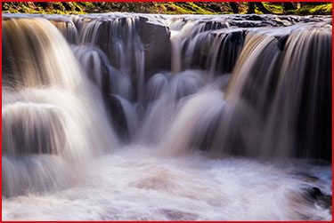
Viewpoint – Falls and bridge: Don’t cross the river but turn right to follow the path alongside the river. There is a memorial stone next to the river and small photogenic falls.
From here the path runs parallel to the river, passing above Water Ark Foss (also known as Upper Thomason Foss)
Bench & Viewpoint – Water Ark Foss: The path reaches a bench set against the fence under some trees. From here there is another view up the railway line. A path to the left allows you to scramble down (carefully!) under the railway bridge to the riverside. Here there are good views up the river to Water Ark Foss, framed by the arches of the bridge. Wellingtons are useful for the best views!
Climb back up to the bench to continue the walk, following the path around the field edge.
7.
The path meets a road at Hill Farm holiday cottages. Follow the road to
the left, turning left again over the railway bridge (with further good
views along the cutting). The road runs downhill into the small hamlet
of Beck Hole.
8.
Just before the road bridge over the river a footpath to the left,
between walls, leads to Thomason Foss. Follow this footpath above and
alongside the river until you reach the falls.
Viewpoint – Thomason Foss: The path ends near the falls, providing more great opportunities to photograph the falls. They are particularly photogenic in autumn.
Retrace your steps back along the footpath to Beck Hole.
9.
The Birch Hall Inn in Beck Hole has, in addition to the bars, a small
shop selling sweets and snacks. Just past the Inn turn right along the
marked bridleway, pass through two gates and then bear left (not
crossing the river).
10.
Incline Cottage take the path to the right alongside the river. Follow
this up a fairly steep climb, along above the river and then down again
to reach a gate and boardwalk.
Viewpoint – Malyan Spout: The path continues alongside the river, with some clambering over stones, to reach Malyan Spout. The falls here are very different to those on Eller Beck, with a long drop. You will need a wide angle lens for the best photos. The path crosses the base of the falls themselves, then continues across two bridges and onwards alongside the river.
11. From here the path alongside the river can be very muddy and eroded in wet conditions. An alternative route is signposted. If conditions allow, the riverside path is very picturesque with many tumbling falls and mossy boulders.
Viewpoints – riverside: There are many spots to photograph the falls and riverside scenery along this stretch of the walk.
12.
The riverside path ends at a road bridge. Turn left up the hill and
take the second footpath on the right past a farm and into the fields
13.
The footpath across the field roughly follows the line of the pylons
(Don’t bear right) until the corner of the fenced field on the right is
reached.
14.
After following the field edge until the corner of the fence turn right
(signposted “Foss”) and follow the edge of the field until the next
corner, then turn right again. The path descends towards the river and
a field wall. Another scramble downwards brings you onto the river bank
just below the falls of Nelly Ayre Foss.
Viewpoint – Nelly Ayre Foss: Nelly Ayre Foss is a lovely small waterfall in amongst the trees. Again a fairly wide angle lens will help with the best views.
From the falls retrace your steps around the field back to the “Foss” signpost, the follow the path to your right, diagonally up over the fields, crossing above the line of the pylons to meet the road.
15. Turn left along the road and follow it all the way back into Goathland – passing the Malyan Spout Hotel on the way.
Refreshments: There are several cafes in Goathland for refreshments. The walk ends back at the car park.
Download a description and map of the route as a pdf file.
View a gallery of photographs taken along the route
See the route on the Viewranger website